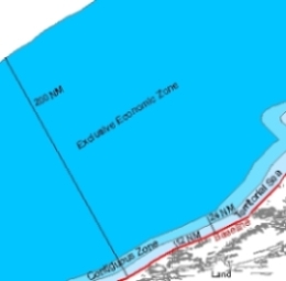
The Maritime Boundaries Geodatabase MARBOUND is developed in 2006 and bundles the boundaries of the Exclusive Economic Zones (EEZ's) of all countries worldwide. The database also includes all original documents of the treaties concerning these borders (in digital format).
As the definition of these demarcations is a relatively new phenomenon, some countries did not mark their marine borders yet. Negotiations will go on in the future, leading to new treaties between countries. Through a forum on the MARBOUND website users can contribute to the further development and optimization of the MARBOUND database by informing us about the newest border-developments. In new versions we will always document what exact changes are performed in comparison with earlier versions.
In August 2009 the version (4.0) was released. It includes the repaired marine borders between Canada and USA and a higher precision of the boundary between Denmark and Germany (at the Flensburg Fjord).
Also this forth version of the MARBOUND database can be downloaded freely on www.vliz.be/vmdcdata/marbound. The package consists of three shapefiles. The first shapefile is a polyline of the marine shorelines worldwide. The second consists of the polygones of the EEZ's. The third shapefile is the elaborated Continental Shelf of Autstralia. Download the complete package.
Soon after its release the MARBOUND database was notified by the Google community and was made visible as an imposed layer for Google Earth. Simply flag on the option 'EEZ boundaries' under the option 'Places'. From then on you can see, at any magnification or projection, the EEZ-borders drawn. However, the Google Earth layer still contains version 1.0 of the EEZ-database.