13 / 10 / 2022
International UN commission issues guidelines
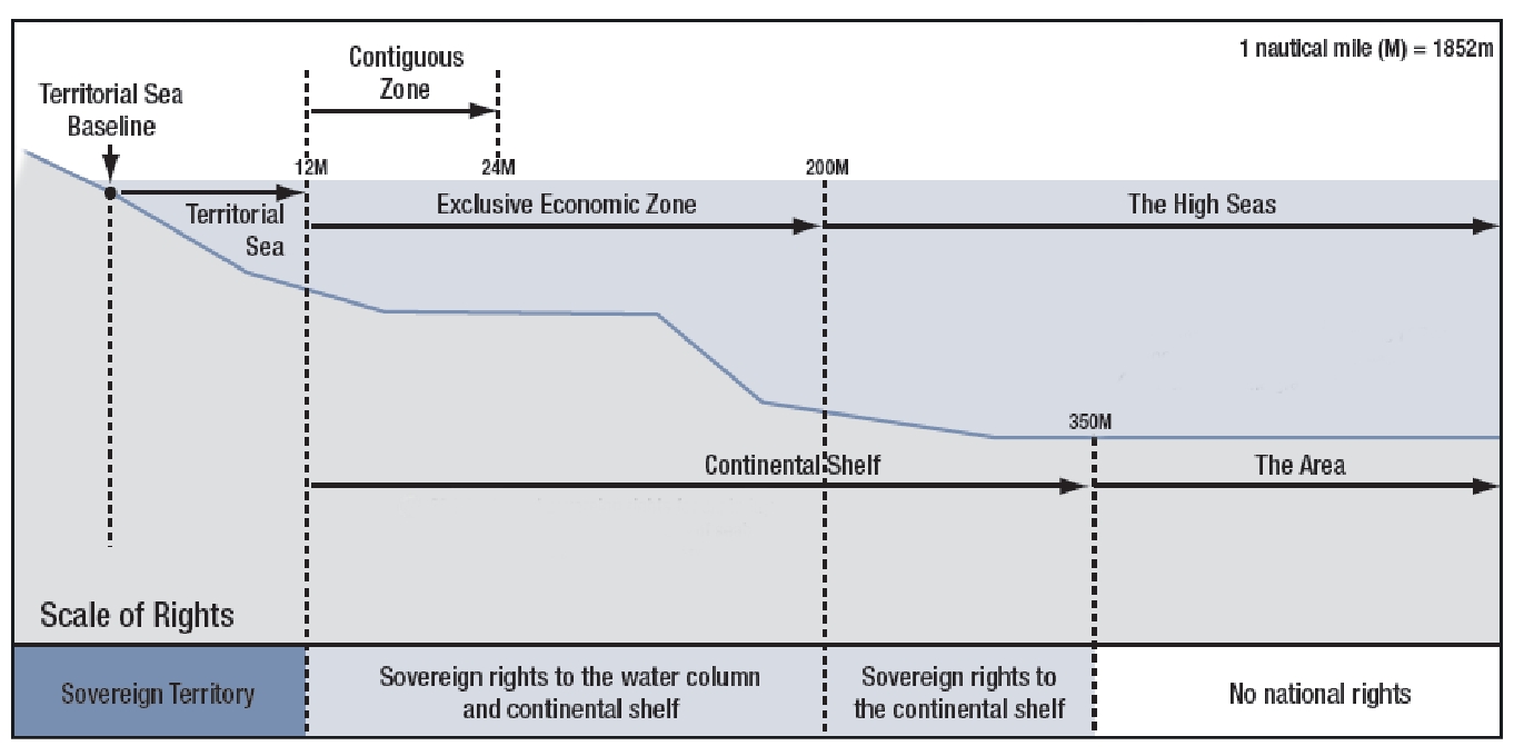
Countries can benefit from an extended continental shelf by submitting a claim to the United Nations Commission on the Limits of the Continental Shelf (CLCS). To do so, they must prove the extent of their extended continental shelf based on geological and bathymetric data. The CLCS assesses the scientific value of these claims, and then makes recommendations to the states.
Bron: https://www.vliz.be/projects/marinegeneticresources/united-nations-convention-law-sea.html
Facts and figures
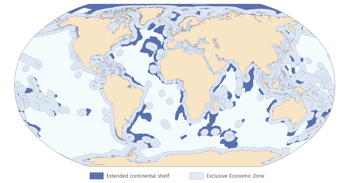
The recently published Marine Regions dataset of extended continental shelves presents all claims up to 1 January 2022, reaching a total of 134 polygons (made up of 47.307 points and 315 lines). The most recent claim is that of Indonesia relating to the island of Sumatra. The oldest dates from 2008 and was made by Japan.
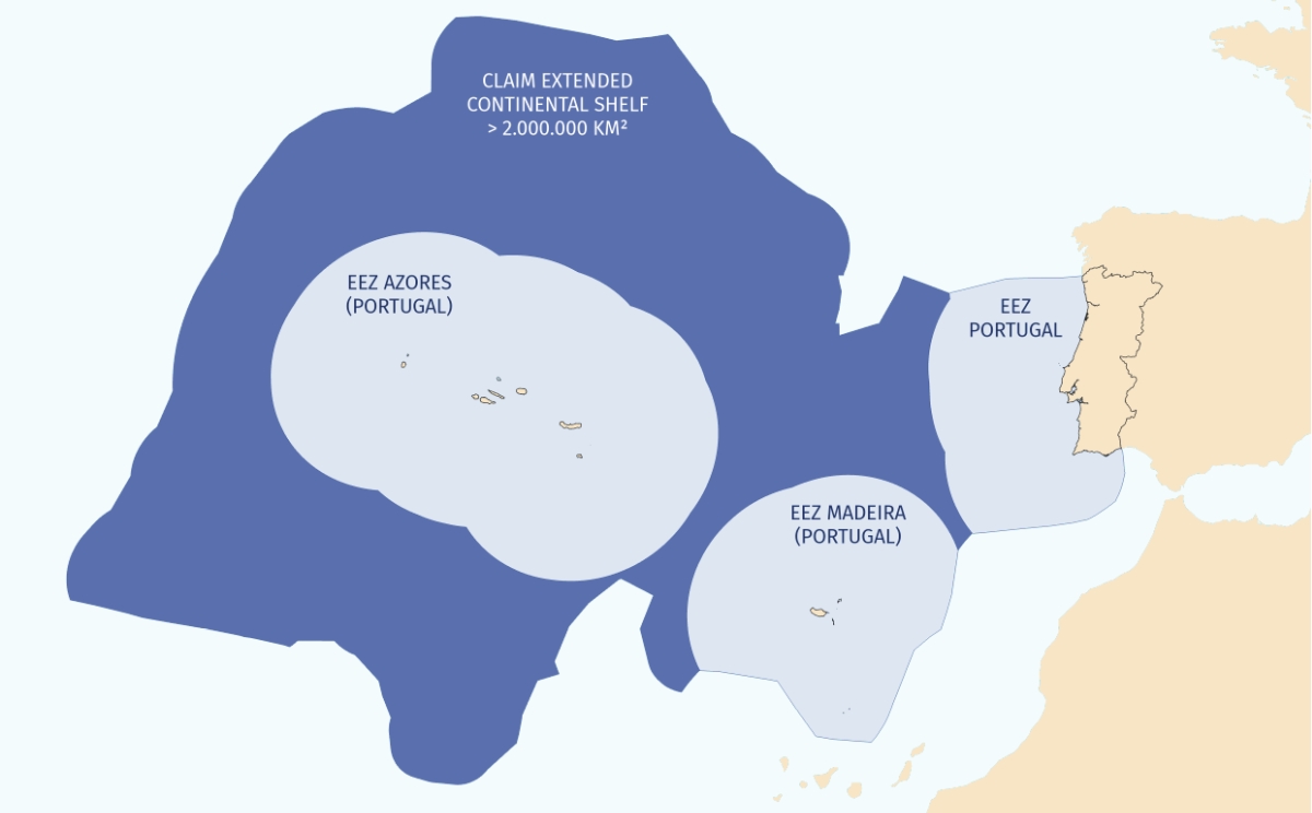
An 'advantageous' location can have a huge impact on the territory a country can claim. For instance, Portugal can claim an area of more than 2.000.000 km², although its land area is smaller than 100.000 km² (even with the Azores and Madeira included). Add to this its Exclusive Economic Zone and Portugal can more than forty-fold its territory!
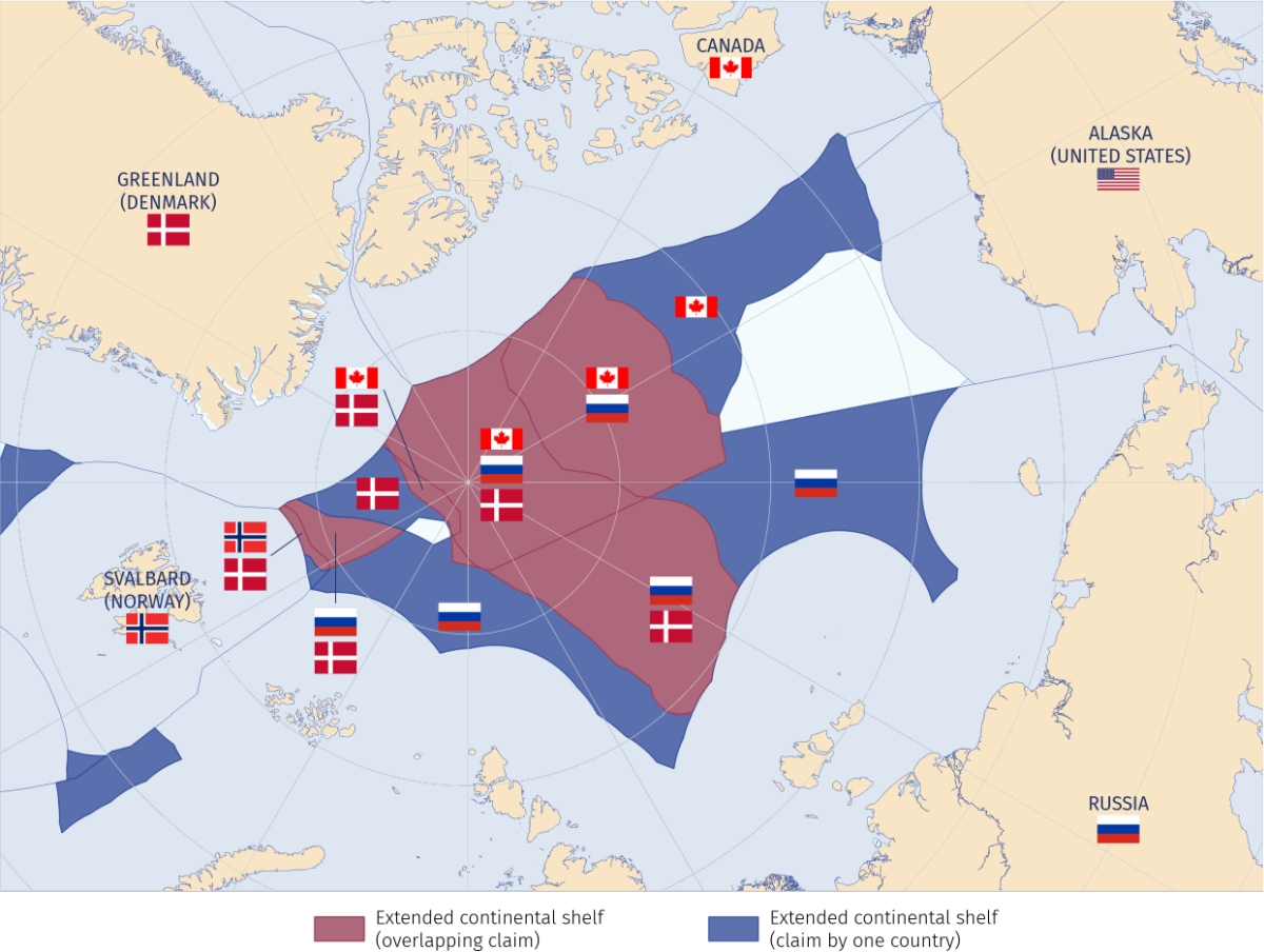
However, besides a number of joint submissions - France, Ireland, the UK and Spain jointly claim an area of almost 80.000 km² northwest of the Iberian Peninsula - there are also 55 polygons that show overlapping claims. The most prominent is the area around the North Pole, where Canada, Russia and Denmark all (should) share the cake among themselves. Due to climate change, natural resources on the seabed and in the subsoil in this area will be more easily accessible in the future. The United States could also have a claim in this region, but it is not a party to the Law of the Sea Convention that created these zones and therefore cannot make a submission to the CLCS.
This new Marine Regions dataset was developed under the Belgian contribution to the LifeWatch research infrastructure and is an addition to the existing database of maritime boundaries, started in 2006. The data can be downloaded from www.marineregions.org/downloads.php#marbound, or visualised and analysed via several web services. The dataset is mainly intended for scientific research and educational purposes.
Countries can benefit from an extended continental shelf by submitting a claim to the United Nations Commission on the Limits of the Continental Shelf (CLCS). To do so, they must prove the extent of their extended continental shelf based on geological and bathymetric data. The CLCS assesses the scientific value of these claims, and then makes recommendations to the states.
Bron: https://www.vliz.be/projects/marinegeneticresources/united-nations-convention-law-sea.html
Facts and figures
The recently published Marine Regions dataset of extended continental shelves presents all claims up to 1 January 2022, reaching a total of 134 polygons (made up of 47.307 points and 315 lines). The most recent claim is that of Indonesia relating to the island of Sumatra. The oldest dates from 2008 and was made by Japan.
An 'advantageous' location can have a huge impact on the territory a country can claim. For instance, Portugal can claim an area of more than 2.000.000 km², although its land area is smaller than 100.000 km² (even with the Azores and Madeira included). Add to this its Exclusive Economic Zone and Portugal can more than forty-fold its territory!
However, besides a number of joint submissions - France, Ireland, the UK and Spain jointly claim an area of almost 80.000 km² northwest of the Iberian Peninsula - there are also 55 polygons that show overlapping claims. The most prominent is the area around the North Pole, where Canada, Russia and Denmark all (should) share the cake among themselves. Due to climate change, natural resources on the seabed and in the subsoil in this area will be more easily accessible in the future. The United States could also have a claim in this region, but it is not a party to the Law of the Sea Convention that created these zones and therefore cannot make a submission to the CLCS.
This new Marine Regions dataset was developed under the Belgian contribution to the LifeWatch research infrastructure and is an addition to the existing database of maritime boundaries, started in 2006. The data can be downloaded from www.marineregions.org/downloads.php#marbound, or visualised and analysed via several web services. The dataset is mainly intended for scientific research and educational purposes.