Off Greenland’s east coast, cold polar water flows south towards the North Atlantic Ocean. But the East Greenland Current does not follow a neat, straight path. It meanders, branches and spins off rotating masses of water: ocean eddies. Although relatively small, from a few kilometers to a few tens of kilometers across, these eddies can transport heat, nutrients, carbon and even pollutants, giving them an important role in the ocean and climate. An international research team led by VLIZ is heading to the Greenland Sea. Using satellites, underwater robots and a research vessel, the scientists will investigate how these eddies affect the East Greenland Current and what that means for a rapidly changing Arctic. Expedition leader Leandro Ponsoni takes us on a hunt for eddies in the Arctic Ocean.
– LEANDRO PONSONI

Ocean eddies in the Gulf stream. | NASA - Goddard Space Flight Center Scientific Visualization Studio
An ocean in constant motion
Look at a map of global ocean circulation and you will see a vast network of currents. Like the atmosphere, the ocean is constantly on the move. Large current systems transport heat and other properties around the planet.
That matters enormously for the climate. Water can store far more heat than land or air, making the ocean a vast reservoir of heat. Ocean waters absorb large amounts of solar energy, particularly in tropical and subtropical regions. Some of that heat is released back into the atmosphere, while ocean currents carry warm water towards higher latitudes.
A familiar example is the Gulf Stream, which carries warm water northwards through the North Atlantic. At the same time, cold currents transport water from the polar regions towards lower latitudes. Together, these currents help redistribute heat around the planet.
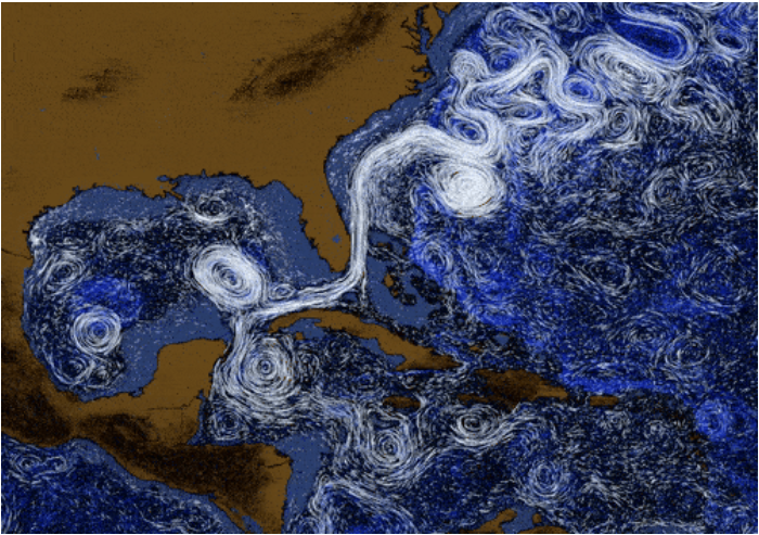
Visualisation of surface currents in the south-western part of the North Atlantic Ocean, focusing on the Loop Current in the Gulf of Mexico and the Gulf Stream along the US coast. Click here to view the full animation. | NASA & USGS
Along Greenland’s east coast, the East Greenland Current (EGC) plays an important part in this system. It carries cold, relatively fresh water, sea ice and a wide range of particles – including nutrients – from the Arctic towards lower latitudes. In doing so, it counterbalances the warm, salty water flowing northwards on the eastern side of the North Atlantic.
Not a straight current, but a sea full of eddies
On a map, an ocean current like this often appears as a single broad, continuous stream. In reality, it is far more unruly. Shaped by the surrounding ocean and atmosphere, the East Greenland Current meanders, splits and forms narrower filaments.
One striking result is the formation of ocean eddies: ring-shaped, rotating masses of water that are somewhat like vortices. They can form, for example, when an ocean current becomes unstable or when different water masses meet.
A meander in a current can eventually pinch off, creating a rotating body of water. An eddy can trap seawater with distinct properties and carry it away from the main flow, or remain in contact with it, continuously exchanging water over time. At the same time, its rotation can alter the direction and strength of the surrounding currents.
This summer, an international research team led by the Flanders Marine Institute (VLIZ) will study these eddies in the Greenland Sea at close range. As part of the E(ddies)GC project, the scientists combine observations from a research vessel with measurements from autonomous robots ánd satellites. Their aim is to understand how eddies interact with the East Greenland Current, and what those interactions mean for the Arctic and the North Atlantic climate system.
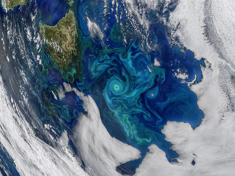
A phytoplankton bloom in the Tasman Sea (2017), captured by NASA’s MODIS instrument on board the Aqua satellite on 21 November 2017. | NASA Ocean Biology Processing Group, Goddard Space Flight Center
Why eddies matter?
Eddies do more than make ocean circulation look fascinating. They can also influence biological and chemical processes, both at the surface and below. Some eddies, for example, bring nutrient-rich water from deeper layers up into the sunlit surface ocean. There, phytoplankton can use those nutrients to grow. In this way, eddies can boost primary production and ultimately affect the entire marine food web. On the other hand, this increased production at the surface, as the organisms die and sink into deeper waters, ultimately contributes to the storage of carbon from the atmosphere in the deep ocean. The size of that effect depends strongly on the type of eddy and the environment in which it forms.
Particles suspended in the water can also be temporarily trapped by an eddy’s circulation or carried elsewhere. This applies not only to natural particles such as plankton and detritus, but also to the many man-made microplastics found in the ocean. Microplastics behave in particularly complex ways: their size, shape and density all influence how a plastic particle responds to currents, turbulence and vertical movement in the water.
Eddies therefore form a link between the ocean’s physical, biological and chemical processes. Their influence extends from marine ecosystems and the carbon cycle to the transport of natural substances and pollution.
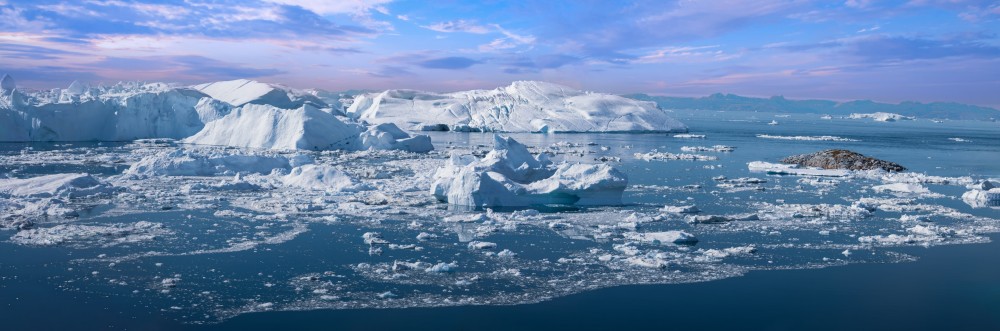
A melting glacier in Greenland. | Shutterstock
The Arctic: a climate-sensitive region
Understanding eddies is particularly important in the Arctic, one of the regions responding most strongly to climate change. Over the past forty years, the Arctic has warmed almost four times faster than the planet as a whole, a phenomenon known as Arctic Amplification. The consequences are profound. Sea ice is declining, the Greenland ice sheet and glaciers are losing mass, and marine heatwaves are becoming more frequent in some parts of the Arctic.
This is also causing the ocean to change. In many places, melting ice, rivers and precipitation are adding more freshwater. This makes surface waters fresher and can increase the ocean’s stratification. A stronger separation between surface waters and deeper layers affects ocean mixing and circulation. That can have consequences for major currents such as the East Greenland Current, but also for the eddies.
A challenging target
Arctic eddies are particularly difficult to measure, partly due to their size. Towards the poles, the characteristic scales at which ocean eddies form become smaller under the influence of Earth’s rotation.
Unlike subtropical eddies, which are typically on the order of 100 km across, eddies at higher latitudes are much smaller – from a few to a few tens of kilometres across – and therefore harder for scientists aboard a research vessel to pick out at sea. Traditional satellite measurements often cannot resolve these small Arctic eddies individually either. In addition, working from a research vessel in the Arctic brings further challenges. Bad weather, sea ice, long distances and limited accessibility make fieldwork expensive and logistically complex. Every opportunity to collect measurements is therefore valuable.
SWOT: a new view from space
The latest generation of satellites is opening up new possibilities. They can detect the small differences in sea-surface height – known as altimetry – associated with currents and eddies. The SWOT satellite (Surface Water and Ocean Topography), a joint mission led by the US space agency NASA and France’s CNES, has transformed the study of ocean circulation from space.
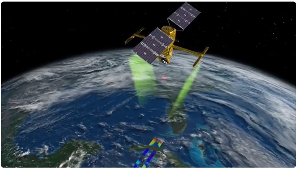
Since its launch in 2022, the SWOT satellite (Surface Water and Ocean Topography) has been collecting data on the height of water across the Earth – in the ocean, lakes and rivers. | NASA Jet Propulsion Laboratory
Traditional satellite altimeters measure sea-surface height along a narrow track directly beneath the satellite. SWOT takes a different approach. Using two radar antennas, it maps sea-surface height across a composed swath of about 120 kilometres wide. This produces a two-dimensional view of the ocean surface. SWOT also provides data at substantially higher resolution than earlier altimetry satellites, with a 2 km grid resolution, making it especially valuable for observing smaller eddies at high latitudes.
Satellites, ships and robots complement one another
But even a sharp view from space cannot tell the whole story. Satellites mainly show what is happening at the ocean surface. To find out about temperature, salinity, currents, nutrients and carbon below the surface, measurements need to be taken throughout the water column. And that is precisely where the E(ddies)GC comes into its own.
The project brings together three ways of observing the ocean: satellites, autonomous underwater robots and a research vessel. The aim is to map the eddies from different perspectives and at different scales. While the research vessel can make detailed, targeted observations over a short period, the autonomous instruments can remain at sea for several weeks.
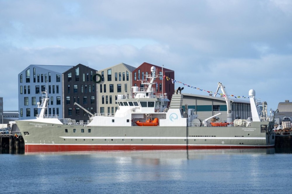
The research vessel RV Þórunn Þórðardóttir moored in the port of Hafnarfjörður, Iceland, the starting point for the E(ddies)GC expedition to the East Greenland Current. | MFRI, Iceland
One of the campaign’s most innovative features is its adaptive sampling strategy. Rather than following a fixed measurement plan, the researchers will continually adjust the track of the research vessel and the glider missions using near-real-time observations from the SWOT satellite. By tracking the location and development of ocean eddies and the East Greenland Current from space, the team can direct its sensors towards the most scientifically interesting locations as they emerge. This allows the researchers to extract maximum scientific value from every measurement made at sea.
The first observations began even before the main expedition. Two VLIZ autonomous underwater gliders, Yoko en Tsuno, were deployed in the Greenland Sea in July from the Norwegian research vessel RV Kronprins Haakon. The gliders move slowly through the water, measuring parameters including temperature, salinity and currents. Throughout their mission, the team at the VLIZ Marine Robotics Centre controls Yoko and Tsuno from VLIZ headquarters in Ostend.
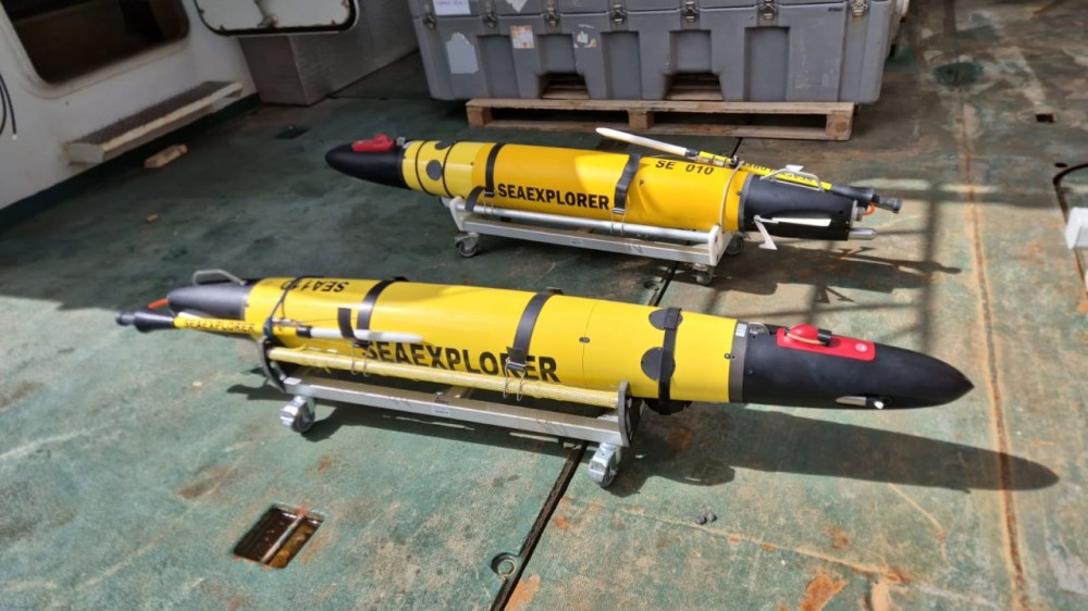
The two gliders, Yoko and Tsuno, before they were launched in mid-July near the East Greenland Current. Since then, their every move has been monitored around the clock from the VLIZ Marine Robotics Centre in Ostend. | VLIZ (Fred Fourie)
The main expedition takes place from 25 August to 3 September 2026 aboard the Icelandic research vessel RV Þórunn Þórðardóttir (pronounced Thorunn Thordardottir), operated by collaborators from the Marine and Freshwater Institute in Iceland. The ship will carry an extensive suite of instruments. CTD sensors will measure parameters including temperature and conductivity (to infer salinity), acoustic equipment will map currents, and water samples will enable chemical analyses. Other instruments will investigate light in the water column, greenhouse gases and microplastics.
No single instrument can tell the whole story. Satellites provide the broad view at the surface. Gliders take measurements through the water column over longer periods. The research vessel, meanwhile, can carry a wide range of specialised instruments and make highly targeted measurements. By combining all these data, the researchers hope to reconstruct how eddies form and evolve, and how they influence the East Greenland Current.
From an eddy to better numerical modelling
The ambitions of the E(ddies)GC project go beyond understanding a single ocean current. Its measurements are also expected to help improving numerical models used for climate modelling and numerical weather prediction.
The representation of the ocean eddies poses a problem for such models. The eddies are often smaller than the grid cells used to represent the ocean. Calculating every individual eddy would require enormous computing power. Their effects therefore often have to be simplified in models, which means some important ocean processes may still not be fully represented in the numerical framework.
The E(ddies)GC measurements provide a reality check. By comparing simulations with observations from ships, robots and satellites, scientists can assess what the models capture well and where improvements are needed. A better representation of small-scale ocean processes could ultimately help us understand how changes in the East Greenland Current and the wider North Atlantic circulation affect the climate.
An international expedition with a strong Flemish contribution
The E(ddies)GC project brings together scientists from different countries and disciplines, with VLIZ as the lead institution. Participants include collaborators from Wallonia, Denmark, Italy, Poland, Iceland, the Netherlands, and United States. The expedition was made possible through the Aquarius Transnational Access Call, a European initiative that supports international access to research infrastructure. Additional support was provided by Departement Kanselarij en Buitenlandse Zaken (DKBUZA).
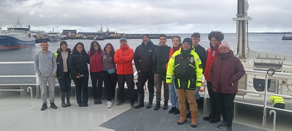
International research team from the E(eddies)GC project just before sailing off on 25 August 2026. | VLIZ
Different research groups at VLIZ are involved in the project: the Marine Robotics Centre, which contributes expertise in glider operations (Fred Fourie, Roeland Develter, Eduard Scheiterer, and Rita Novo) and physical oceanography (Leandro Ponsoni, Chiara de Geeter, Christophe Maier, and Wieter Boone); the Research Infrastructure Division, which contributes expertise in carbon measurements (Coraline Leseurre, Hannelore Theetaert, and Thanos Gkritzalis); and Ocean Health and Human Health, which contributes expertise in microplastics (Xiebe Stiers, Mattias Bossaer, Ana Catarino, and Maarten De Rijcke).
The timing is significant. The Arctic is changing rapidly, while many of the processes driving those changes remain difficult both to observe and to model. By bringing together researchers, technology and observations from different countries, E(ddies)GC aims to close some of those knowledge gaps.
Because however small an ocean eddy may seem on a global scale, what happens in the cold waters around Greenland can help determine how we understand the much bigger puzzle of the ocean and climate.
Read more
- An Ocean in Motion: NASA's Mesmerizing View of Earth's Underwater Highways | YouTube
- E(ddies)GC: Multifaceted Impacts of Eddy Activity on the East Greenland Current | AQUARIUS website
- Exploring High-Resolution Sea Surface Height Data from NASA’s SWOT Satellite | NASA website
About the author
Leandro Ponsoni is a researcher at the Flanders Marine Institute (VLIZ) specialising in physical oceanography, cryosphere and climate research. His work combines in situ observations from research vessels and robotic platforms, satellite observations, and model outputs to study ocean and climate processes. Leandro leads the international E(ddies)GC project.