The EU is providing €13.2 million for in-depth research into the drowned and buried landscape of the North and Baltic Seas. Scientists from Flanders Marine Institute will join forces with the University of Bradford, the Geological Survey of the Netherlands and the University of York in a shared quest to explore traces of buried Stone Age settlements.

With this substantial grant from the European Research Council (ERC), Europe funds excellent research. This is the first time that VLIZ joins this type of exclusive 'ERC Synergy Grant' support instrument. Such grants are only awarded to large-scale umbrella projects that require collaborations of several outstanding institutions to achieve their ambitious goals.
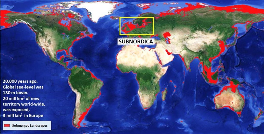
Focus of the SUBNORDICA research is the 3 million km2 of new land exposed during the last Ice Age in North and Baltic seas when sea levels were more than a hundred metres lower than today. These coastal plains, lakes, river valleys, shorelines and offshore islands were very attractive as prehistoric settlements. The landscapes have since been drowned due to global climate change, but still remain almost entirely unexplored. Today, these landscapes and the traces and remains of settlement preserved in them are under threat as the world develops the coastal shelves to meet net zero goals.
Dr Tine Missiaen, marine geophysicist (VLIZ): "The SUBNORDICA project offers a unique opportunity to understand what landscapes looked like in the Stone Age, and their rapid evolution after the last Ice Age. With advanced technology and AI, we should be able to understand this unique fragment of European prehistory."
The EU has provided funding of €13.2 million for SUBNORDICA - a research collaboration between Moesgaard Museum, Aarhus University, the University of Bradford and the German research institute NIhK, to explore landscapes and settlements submerged by these seas. Researchers from the University of Bradford, together with the Flanders Marine Institute (VLIZ), the Geological Survey of the Netherlands (TNO), and the University of York, will lead the exploration in the southern North Sea.
Dr Ruth Plets, marine geologist (VLIZ): "In recent years, the VLIZ has made significant investments in geoarchaeological research of the Southern North Sea. We are therefore very pleased that this ERC grant will allow us to work even more closely with key European colleagues from 2024 onwards. By working together and exploring new technologies, we will be able to collect a lot of additional data and integrate it across borders. This will allow us to significantly increase our knowledge of prehistoric drowned landscapes in NW Europe."
The SUBNORDICA project will apply the latest technologies to map the seabed. AI and computer simulation will be used to identify areas where long-lost settlements may still survive and can be explored. This will lead to a deeper understanding of how our ancestors lived in areas that are now under the seabed.
At the same time, this research enables ethical development of the seabed. The pressure on the North and Baltic Seas from new economic activities (such as renewable energy) is very high and will further increase in the coming years and decades. In Belgian waters, the new Princess Elisabeth-zone, covering an area of 285 km², will result in an additional offshore wind capacity of roughly 3.5 GW (covering over one quarter of the Belgian energy consumption). Unwanted impacts of such large-scale development on and in a seabed with proven archaeological richness can be limited through knowledge generated by large-scale transnational studies like SUBNORDICA.

