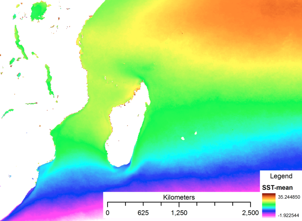
OceanographyThe oceanography of the Western Indian Ocean is dominated by three features arising from its geology and tectonic history – the Asian landmass in the north, the island of Madagascar, and the Mascarene Plateau – and their interactions with the equatorial and western boundary currents of the Ocean basin. The Asian landmass drives the seasonal monsoon system that dominates the climate of this region of the globe, while Madagascar and the Mascarene Plateau interact with the currents imparting meso-scale (features on a scale of about 100-500 km) dynamics that are unique to the ocean. The dominant features of the oceanographic processes in the WIO are:
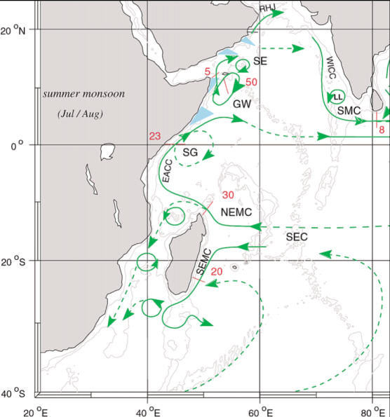
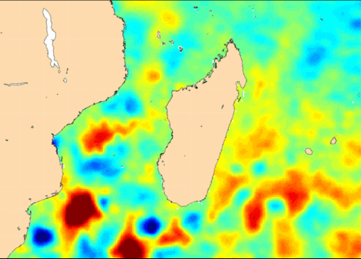
The South Equatorial Current (SEC) enters the WIO as a broad slow surface current stretching from about 5-16°S, fed from the Indonesian Through-Flow with waters from the Pacific, and passing by the Chagos archipelago at its northern edge, which forms a significant stepping stone for species and genetic connectivity. At the Mascarene Plateau the SEC is partially blocked, with 50% of its flow forced through the narrow gap between the Saya de Malha and Nazareth banks at about 12°S, a small proportion flows north of Saya de Malha to the main Seychelles Bank, and the balance flows south of the Cargados Carajos bank, concentrated at about 17-18°S. Approaching Madagascar, the main flow of the current is at about 17°S. In the Mozambique Channel, the tip of Madagascar Island, the Comoros-Glorieuses chain, and the narrowest point in the channel, at 16°S, interact with the flow of the SEC and open ocean features such as Rossby waves to generate unique and highly dynamic meso-scale features. The “Glorioso Front” likely marks the transition from the SEC to the waters of the channel, where a series of cyclonic and anti-cyclonic eddies and an intermittent gyre around the Comoros chain are induced. Driven by these features, water may flow in any direction resulting in a highly mixed and dynamic water body, with a more concentrated southward flow starting at the channel narrows extending in a narrow jet of highly dynamic water offshore of the Mozambique coast. Complex forcing of biological parameters results from these dynamics, including up- and down-welling in the eddies and their interactions with the continental shelves and slopes below at least 1000m depth. As a result, the Mozambique channel is one of the most energetic western boundary zones of all the world’s oceans.
Ocean-climate interactions - The Western Indian Ocean interacts with regional and global climate systems on three scales – seasonal, interannual to decadal and over the long term. The monsoon seasonality of the Indian Ocean is perhaps one of the strongest ocean-climate interactions on the planet. Driven by the summer-winter oscillation of solar heating over Asia, it results in oscillating trade winds and associated shifts in currents in the Indian Ocean. During the southern winter, when the sun is over Asia and North Africa, the resulting low pressure system sucks in air masses from the south resulting in southeasterly winds, associated with cooler temperatures and generally rough conditions in the Indian Ocean. During the southern summer, northeasterly winds are established drawing hotter dry air from Asia and the Sahara southwards. In between these seasons, calmer inter-monsoon doldrum conditions prevail. The alternating winds cause current reversals in the northern part of the Indian Ocean, where the Somali Current and northern Indian Ocean gyre oscillate between the seasons. The monsoon does not reverse currents in the south, but it does strongly modulate their speed and variability. Variability among years is due to the Indian Ocean’s equivalent of the Pacific Ocean’s El Niño Southern Oscillation (ENSO), known as the Indian Ocean Dipole (IOD). As with the ENSO, the IOD reflects differences in sea surface temperature, and therefore rainfall and winds, between the eastern and western parts of the ocean, moderating seasonal conditions across the ocean. These patterns of variability are further influenced by other oceanographic features of the WIO, including a Seychelles-Chagos ‘ridge’ in the thermocline that affects sea surface temperatures and thereby ocean-atmosphere interactions, and decadal features similar to the Pacific Decadal Oscillation (PDO). With relevance to long term global climate trends, leakage of Agulhas Current rings into the south Atlantic may be among the main controlling factors affecting climate dynamics historically, and perhaps under a changing climate, due to their role in the ocean circulation conveyor belt. Paleo-oceanographic history - Little is known about the oceanographic history that influences the WIO, but emerging research is highlighting some key features that may have contributed to today’s unique features in the WIO. Until the closure of the Tethys Sea (30-15 mya), it is likely that ocean currents linked the Tethys and the WIO. Equatorial currents crossing the Indian Ocean from east to west were first blocked by India as it migrated northwards (65-40 mya), and then likely by the string of islands and banks produced by the Mascarene-Reunion hotspot (45-20 mya) that now form the Mascarene Plateau. Further, before the Miocene, there was very little development of the shallow marine communities that are dominant today (e.g. coral reefs) in what is now southeast Asia. These communities only began to form at the start of the Miocene, 24 mya, when the Australian and Asian plates collided and formed the Indonesian island arc. As a result, up to 24 mya it appears that shallow marine habitats in the WIO had a primary connection with the Tethys Sea as it closed, and only subsequent to that, a primary connection with the emerging center of diversity in the Southeast Asian region.
Key References - Beal et al. (2010); Belkin & Cornillon (2007); Guyomard et al. (2006); Hermes and Reason (2008); Lutjeharms (2006); Obura (2011); Palastanga et al. (2006); Penven et al. (2006); Ridderinkhof et al. (2010); Saji et al. (1999); Schott and McCreary (2001); Schott et al. (2009); Ternon et al. (2012). --> References |
Assessing potential World Heritage marine sites in the Western Indian Ocean |


Website developed and maintained by VLIZ
