Timeline R/V Belgica cruise ST0813:
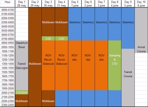
The study area is located on the Armorican Margin, at water depths between 250 and 1500 m, within the area: 5°50’W/4°50’W/46°30’N/47°10’N. The area in between the Audierne and St. Nazaire canyons (Gascogne area) along the French Armorican margin was one of the areas where the "massifs coralliens" were described for the very first time (Le Danois, 1948). A compilation of historical studies which have retrieved deep-water corals indeed indicate this area has a high potential for coral growth (Réveillaud et al., 2008). Within the framework of the HERMES (EC FP6), MiCROSYSTEMS (ESF) and GeNeSis (FWO) projects, this area will be surveyed using multibeam and high resolution seismic profiling during LEG 1 of campaign 08/13. Based on the results of this site survey, the ROV Genesis will be deployed to carry out detailed mapping of these deep-water "hot-spots". Also the hydrography and sediment dynamics of this area will be studied with respect to the steering of the present ecosystems.
This campaign will be executed in cooperation with the department DRO-DEEP/LEP of IFREMER (France).
This campaign will focus on the following objectives within the study area:

Planning schedule leg 1 (28/05/2008-06/06/2008)

General localization of the study area along the Armorican margin (GEBCO contour lines every 250 m)

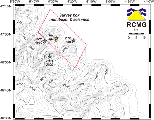
Survey area and stations along the Gascogne drainage basin (GEBCO contour lines every 100 m). Red: multibeam box, orange star: ROV stations and green stars: CTD-SVP sites
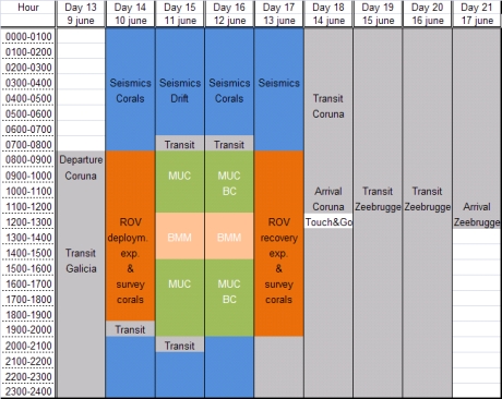
LEG 2 of campaign 08/13 will focus on the Galicia bank, a seamount 200 km west offshore the Galician coast of Spain. Several institutes are participating in this cruise, each with their own scientific objectives.
The Marine Biology Section of Ghent University will try to characterize the meiobenthic community (and more specifically the nematodes) concerning their biodiversity and diet (the latter by means of stable isotope and fatty acid analyses). This is done in the framework of the European project BIOFUN which stands for “Biodiversity and Ecosystem functioning in contrasting Southern European environments: from viruses to megafauna”. The overall aim of this project is to characterize two deep-sea habitats (mid-slope & abyssal plain) to understand the linkages between biodiversity patterns and ecosystem functioning in relation to environmental conditions. For this purpose, investigations will be done (in coordination with other institutes) at selected deep-sea sites from contrasting environments along a gradient of increased oligotrophy from The Galicia Bank in the Atlantic, to the western Mediterranean and the central Mediterranean. Secondly, in the framework of the HERMES project a phylogeny/ phylogeography study will be conducted on sponges associated with cold-water corals. The aim is to assess the possible connection of coral and associated fauna along the European margin as well as the health of the gene pool of these sponges in different areas. Coral thickets occur as isolated patches on the summit of the Galicia Bank (at ± 700 m water depth). They will be sampled with a boxcorer and/or an ROV.
The geographical and bathymetrical distribution of certain copepod species will be studied by Forsuchungsinstitut Senckenberg. Many marine benthic copepods from shallow waters and the deep sea show a worldwide distribution although they do not have a planktonic larval stadium. In this context the relevance of seamounts for the dispersal of marine benthic copepods has been discussed during the last years. Seamounts, being characterized as stepping stones, may provoke the distribution of species but may also function as a trap, generating the formation of a discrete community. Data gathered during this campaign will be compared with results from other seamounts (Great-Meteor, Sedlo, Seine, etc.). In addition to biological sampling, also seismic surveying is planned here in cooperation with the Renard Centre of Marine Geology (RCMG) and the Instituto Espanol de Oceanografia (IEO).
This campaign will focus on the following objectives within the study area:
From the Management Unit of the North Sea Mathematical Model (MUMM) people working on 2 different projects will join the campaign.
The general objective of the BELSPO-funded BELCOLOUR-2 project is to improve the quality of existing optical remote sensing products for marine, coastal and inland waters based on new scientific knowledge and to develop new products (including partial pressure of CO2 and primary production) for key applications such as aquaculture and air-sea CO2 flux quantification. In addition to algorithm work and image processing BELCOLOUR-2 participates in seaborne cruises for the purposes of calibration of algorithms and for validation of the end products. MUMM’s contribution to the BELCOLOUR-2 measurements consists of reflectance, suspended matter and phytoplankton pigment measurements for use in satellite image validation (if cloud-free) and algorithm calibration and validation. The primary objectives of this campaign are making in-situ measurements simultaneous with satellite overpasses of MERIS (Medium Resolution Imaging Spectrometer) and MODIS (Moderate Resolution Imaging Spectrometer). The objectives of the MARIN project are based on previous experience to identify marine mammals and seabirds species inhabiting shelf waters of the Atlantic margin and in the Channel and to estimate their abundance.
From June 9 till June 17 two employees of a tv production company from Berlin, Germany which produces scientific documentaries for the broadcast station Arte (www.arte.de) will join the Belgica campaign. They intend to make a documentary about seamounts. The main focus would be on the research of Christoph Plum (Forsuchungsinstitut Senckenberg).

Planning schedule leg 2 (09/06/2008-17/06/2008)

General localization of the study area along the Iberian margin (GEBCO contour lines every 250 m)

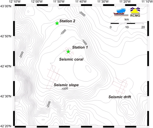
Survey area and stations on the Galicia bank (GEBCO contour lines every 100 m). Red: seismic profiles, green stars: ROV and sampling stations