VLAAMS INSTITUUT VOOR DE ZEE
PLATFORM VOOR MARIEN ONDERZOEK

On this page you will be able to read the daily reports.
Click on the day and the report will show up, click again and it'll disappear.
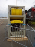
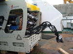
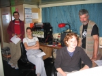
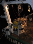
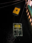
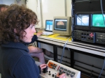
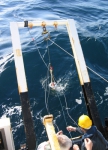
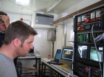
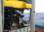
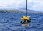
Clear and warm weather, temperature between 21 and 25 degrees Celsius, S/SW-ly winds. Yesterday we arrived in the harbour of Brest, where the R/V Belgica was already docked since Sunday in the late afternoon. Today all the scientists and especially the engineers are in full action to prepare all the labs and the equipment. Koen, Jeroen and Wim are preparing and testing the last details of the ROV (Remoted Operated Vehicle) together with an engineer from sub-atlantic Aberdeen, the factory where the ROV is built. Prof. Dr. Jean-Pierre Henriet suggested a new name for the ROV: 'GENESIS', inspired by a lot of big projects which made it possible to build this Belgians first robotic underwater system for deep-sea research. GENESIS, the origin of new science! Peter installed the seismic equipment together with some help of the students, Frederik and Katja. Seismics is an acoustic technique, used quite often in exploration and industry, whereby a trigger system creates a soundwave which propagates in the water column and reflect on the seabottom and each kind of reflector in the sediments (faults, the transition from hard to soft sediments and the other way around, etc.). The reflected signal is then recorded in function of the time. Each type of sediment or structure has its typical seismic signature. By doing seismic surveys, scientists get an idea what's happening below the seafloor. Veerle and Anneleen tested the multibeam system. Multibeam makes it possible to map the seafloor in detail to create bathymetric charts (= a map illustrating the topography of the sea bottom). The CTD to acquire temperature, salinity and sound velocity profiles from different water masses, is checked and prepared. The Boxcore-systems, sampling gear to take surface samples from the seafloor, are fixed on the back deck of the ship. And to be complete, we set up a first test-satellite connection with the Maria-von-Lindenschule in Heidenheim and the Atheneum in Gent (Belgium). So, action everywhere (preparation is important, once you are out at sea you have to be prepared for everything!). Let's go…
 |
 |
We are still in harbour! Yes, the first problems arrived already and we are not yet out at sea. The main problem is a defect at the optical fibers of the ROV, the cables transmitting the data from the ROV to the work-container on the ship. When these things were fixed, everybody was ready for a final test but then the spotlights from the TMS didn't work. And some light to work on depths below 200 meters is more than useful! However, due to these practical problems we all saved some time and could prepare some other useful things. Veerle, Anneleen and Erwan prepared a GIS-project for the first study area 'Banc de la Chapelle', to plan the navigation tracks for the multibeam. A GIS is a Geographical Information System which makes it possible to integrate all kind of acquired data from the seafloor in a georeferenced system. It is based on a concept of different layers, where you put one layer digitally over another layer. So, you have for example a bathymetric map of the seafloor as base layer and project on that map a layer with the multibeam tracks, a layer with different sample points, dive tracks, etc. A final satellite test-connection was again established between the Maria-von-Linden Schule in Heidenheim (9.00 a.m.) and the Atheneum in Gent (16.00 p.m.). And, last but not least, the Irish scientist Andy, had some problems with his luggage. He arrived yesterday evening in Brest, but his luggage was still somewhere in Paris. So, today he could fetch his pack. So, a quite nervous day for our engineers BUT it's better to have these problems in the harbour than in the middle of the sea…
 |
 |
 |
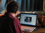
This report picks up at 9 p.m. on the 13th of June. Prof. Dr. Jean-Pierre Henriet gathered us all for a briefing. We discussed the plans for the upcoming 24 hours while the engineers fixed the last technical problems with the ROV. Around midnight we all witnessed the first successful test of the ROV "Genesis" in the water of the harbour of Brest. This was of course a very exciting moment which gave the official go ahead for the ±12h during transit towards Banc de la Chapelle, our first destination. We left at 2 a.m. when everyone except for the responsible crew members went to sleep. Few of us which were already awake around 7.30 a.m. experienced a 6-7 Beaufort sea state (which honestly made my knees shake, turned my stomach upside down …). As weather prospects didn't look much brighter for the rest of the day and working in this sea state was to risky, we decided to return the ship to a safer location: the Bay of Douarnenez, south of the harbour of Brest. Around 2 p.m. the Belgica took a stationary position in an area were depth was about 20 meters, current speeds were modest and sea state was very calm. This gave the pilots of the ROV the excellent opportunity to gain first experience in directing the ROV in the right path and handling the camera device and operational arm. In the meantime the satellite communication took place at the bridge with the Maria-Von Linden-schule in Heidenheim (Germany). During 20 minutes pupils got there burning questions answered by the scientist with the right expertise. The weather was fine, the first images were great, no big problems occurred, in other words everyone had pleasure in it! However, there could be one obstacle influencing further operations: the cable connecting the ROV to the remote control and providing electricity lacks buoyancy and scours the seabed surface…
 |
 |
 |
 |
 |
 |
 |
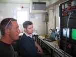
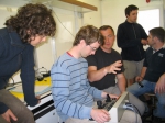
This morning at 8 o'clock, the ROV practice started again. The goals of this session were to control the ROV while the ship is moving forward at a low speed and to keep the cable off the ground during the ROV flight. To succeed in both goals, we had to keep the ROV within a 20m limit from the TMS (= ROV cage). Since we fly away from the ship to avoid any interference between ship and ROV, the ROV was pulled back by the ship. As a result, the forward looking camera was recording a backward moving seafloor and with the backward looking camera we could see what was lying ahead. The world in reverse! During this session, all potential pilots practised their skills in flying the ROV and manipulating the ROV's arm. At the end of the session, even the students got a chance to try out the ROV!
At noon, we left the Baie de Douarnenez and headed towards the Chapelle Bank, a transit that takes about 12 hours. The Chapelle Bank is situated near the margin of the European continental plate. Within a range of 50 kilometres, the depth falls from about 250m at the down to 4000m below mean sea level in the abyssal plain. This range, where the depth increases rapidly, is called the continental slope. The continental slope is incised with several canyons.
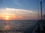
We arrived at the Chapelle Bank around sunset. From now on, the scientific crew works in watches of 3 hours. The first thing, we are doing here is making a detailed map of the seafloor topography using the multibeam echosounder, which is necessary for identifying interesting dive locations. The multibeam echosounding will take the whole night. Tomorrow morning, we plan to dive the ROV and to explore the seafloor along the continental slope near the Banc de la Chapelle. We expect to see corals and sponges, but you never know what the depths of the sea will reveal. What shall we see down there?
 |
 |
 |
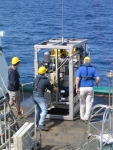 |
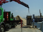
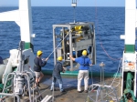
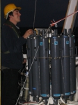
As already told yesterday, we acquired, during the night from Thursday to Friday, a multibeam map around some canyon heads in the neighbourhood of the Chapelle Bank. Before that, a CTD was taken to obtain a sound velocity profile from the different water masses, which is necessary for the calibration of the multibeam system (CTD stands for 'Conductivity, Temperature and Depth probe', and it measures exactly those parameters. The conductivity of the water is caused by its salinity. Using a known equation, we then could convert the salinity and temperature information into a local sound velocity at each depth). After 8 hours acquisition of multibeam data, we were all really curious for the first deployment of the ROV in deeper water. For the positioning of such a ROV, it's necessary to set up a USBL-system (Ultra Short BaseLine System). A transponder with well-known position is fixed overboard and makes connection with transducers on the ROV through an acoustic signal. Based on the "Doppler-effect" and the relative motion of the ROV (with the transducers) towards the transponder, it is possible to get the exact position of the ROV relative to the ship. This is of course necessary when you go down with such a system! Otherwise you are lost in the deep blue…
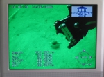
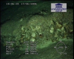
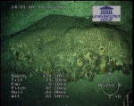
At 9.00 o'clock the ROV went down, aiming for a depth of 550 m. But an alarm in the container pointed out that there was something wrong with the oil pressure. The chamber containing the connections between the electronic cables is balanced against the high pressure in the deeper water by filling it with oil. It is crucial to have this oil pressure under control. So, we had to take up the ROV on board again to get the problem solved. Our chief scientist called it "children's diseases from our new ROV". However, a first successful dive could be established at 16.00 o'clock. The ROV went down in one of the canyon heads. It was a technically difficult operation but we succeeded and got an idea about the geological structure of these canyon heads. The bottom seems to be covered with muddy material, while the flanks are built up of harder banks, providing hard substrates for all kind of epifauna (sponges, etc…). We didn't see any corals yet, but we are looking forward to seeing them during some new dives tomorrow morning (let's keep the fingers crossed). This night we started some seismic exploration in the study area.
 |
 |
 |
 |
 |
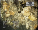
Friday to Saturday night was dedicated to seismic surveying on the Chapelle Bank. While doing seismics, the ship sails at a low speed of just a few knots in order to acquire proper and nice data. In the early morning the seismic survey was finished and we deployed the ROV back into the water for another day of seafloor investigations near the Chapelle Bank. During the ROV-dive of more than 7 hours, some wall-like features (falaises or scarps) showed up, approximately 10m in height and covered with oyster beds. In the neighbourhood of the oyster beds some fish occured; they probably profit from shelter provided within the oyster beds. The oysters feed on organic matter that is produced by phytoplankton in the surface ocean. Phytoplankton occurs in huge amounts in the surface ocean and converts carbon dioxode and solar energy into organic matter. A part of the phytoplankton is consumed by zooplankton, which on their part are eaten by bigger organisms. All organic matter that is not eaten and that doesn`t float - a part of the remaining phytoplankton, dead organisms and excrements - will sink down to the bottom and will pile up on the seafloor, forming so-called 'organic fluff' on the seabed. It rests on the sediment and slowly becomes incorporated into it as burrowing animals turn the sediment over (much like the worms in our garden). Since vertical walls are too steep for sedimentation, oysters can attach on these walls and filter organic matter out of the current-driven water. Last but not least, we saw some some small coral patches, mainly Lophelia pertusa and Desmophyllum sp.
In the evening we had to deal with a dilemma. The first option was to stay in the area of the Chapelle Bank to complete the seismic lines and continue the ROV operations near the seafloor. The second option was to go to the Porcupine area (off the Irish West Coast), to investigate in more detail some small cold water coral mound features, called the Moira mounds. After a discussion, the complete scientific staff agreed to head towards the Porcupine, a transit of more than 24 hours…
 |
 |
 |
This transit day towards Porcupine Seabight (26 hours) made it possible to take some extra hours of sleep. Onboard of a scientific research vessel, things are going on for 24 hours. So, not that much time for a quiet sleep… transit-time is the only way to gather some extra sleep!
For most of the people onboard the day started off around 11 a.m. (after a long sleep) with the traditional Sunday aperitive served by the crew in the wet lab (= the lab onboard where all the samples are cleaned and labeled when they come straight from the back deck). After a delicious meal, we discussed what the day would bring, dependent on the weather. After a few hours of experiencing the strength of the ocean swell and based on the weather forecast it became clear that we wouldn't be able to use the ROV without taking major riscs to damage it. This meant that heading towards Porcupine Seabight was cancelled and an alternative was brought up. We decided to change course and to head towards Bantry Bay (South Ireland) where we'll seek shelter and further optimise the ROV skills. During transit hours, we took the time to digitilize video images we recorded yesterday at the Chapelle Bank. We traced the most interesting sequences in which oyster banks occurred along the downward slope of the spur and tried to identify the different species of these dense and diverse aggregated communities. Further processing of the navigation data was also performed to obtain the track of the ROV dives and to be able to locate the recorded images in a GIS-system (Geographic Information System).
 |
 |
 |
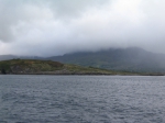
We got up this morning with views on a beautiful, green country: Ireland. Anchored in Bantry Bay, we could see the wild landscape around the bay wake up under low clouds and fog patches. Here and there sunrays had found their way through the clouds, lighting up patches of rock, meadows or the water of the bay. The smell of countryside and peat was in the air. Indoors, the smell of fresh croissants was calling us to the breakfast table, where we heard the planning for the day. After listening to the latest weather forecast and looking at the up-to-date weather maps, the chief scientists and officers had decided that the weather out in the open ocean (i.e. the Porcupine Seabight) would be too rough, at least in the morning, to do any kind of work, either ROV diving or boxcoring. So we decided to stay in the bay and use the ROV to visit some locations suggested to us by a friend of Andy, an enthusiastic scuba diver.
The first spot where we lowered the ROV was exactly where we were anchored. It turned out to be a sandy area with small ripples on the seafloor, but with a very low amount of benthic macrofauna. The only animals that really took our breath away were large numbers of jellyfish floating in the watercolumn. They looked very majestic, elegant, but also dangerous!
The second dive site was located along a steep rocky slope of the bay. Also the seafloor here was very rocky with only patches of sand in between. Plenty of space for all kinds of sessile fauna to find a spot to anchor on! Sea urchins, kelp, sea stars, sponges, sea cucumbers… And several species of fish swimming in between.
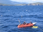
While carrying out these dives, the wind didn't loose in force, on the contrary. We could see how the large swell was coming into the bay from the open sea. Hmmm, this didn't really look very encouraging to go and work in the Porcupine Seabight any more! And indeed, unfortunately, we had to give up any plans to gather any more data in that area… We all felt a bit sad about this, but still, we didn't want to waste any shiptime, so it was decided to investigate another part of Bantry Bay with the ROV. However, once we arrived there, we heard a strange noise in the ships propulsion. Some floating fishing nets nearby gave us an indication of what might have happened already… Hence, the ROV survey was converted from 'seabed study' to 'ship inspection'. Our ROV pilots normally try to stay away from the ship as much as possible, in order to avoid any collisions or accidents, but this time, after the ship anchored safely, they actually came very close to have a good look. This was not an easy task in the strong currents of the bay, but they did very well! And yes, it appeared that part of a line was caught by the propellor. However, it wasn't an extremily dangerous situation, and it was decided that the line would be removed in Cork by professional divers.
After all this, we had a couple of hours left for one more dive, and tried the northern side of Bantry Bay again. The seabed and faunal associations there are fairly similar to those at the southern side, where we investigated the rocky slope in the morning. Time for the ROV to come on deck and finish the cruise. But well, it wasn't our most lucky of days, apparently, because the little winch of the so-called 'tether management unit' of the ROV refused any further work, which made the recovery of the ROV in the normal way impossible. The engineers, together with the ship's crew very quickly came up with an emergency recovery plan, and once everybody agreed on the details of it, the entire operation to bring the ROV safely back on deck only took 10 minutes! Again a very impressive action!
After all this, we called it a day and started preparing for the transit to Cork. Currently we are still anchored in Bantry Bay, while everybody is fixing and securing equipment and personal belongings. On the after deck the engineers are still repairing the ROV and winch unit, but once that's finished and these pieces of equipment are safe and secure too, we can leave for the final transit of the cruise. One that promises to be rather 'bumpy'…
 |
 |
 |
 Monday 12 June 2006