VLAAMS INSTITUUT VOOR DE ZEE
PLATFORM VOOR MARIEN ONDERZOEK

Today is the first day of our trip. We (the Moroccan team) all met in the Faculty of Sciences in Rabat.
On our way to Erfoud we stopped at various interesting geological structures and phenomena. Below a report of our voyage is written.
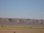
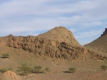
We drove through the occidental Meseta (= plateau) formed at the time of the Hercynian mountains (a period of mountain formation between 300 and 390 Million years ago). It consists of the Coastal Meseta and Interior Meseta, where we find the central massif. This is an extension basin where there are magmatic intrusions, and the Paleozoic (542-251 Ma) basement (strongly deformed rocks) is covered by a Mesozoic quasi-horizontal layers.
Next we crossed the Middle Atlas and had a break in Ifran city, a very beautiful town. People often called it the small Switzerland as it was known for skiing.
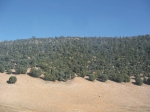
After the break we saw the Cedre Gouraud. This is a Cedar forest with a lot of monkeys, we took some photos and fed them. It was very funny.
The Middle Atlas separates the Meseta in two parts: the occidental part in the west and the oriental in the east. The Middle Atlas represents an intra-continental rifting system with a filling of silty-clay sediments and basalt (a kind of magmatic rock). Contemporary with the Atlantic opening a carbonate platform was formed.
After the Middle Atlas we drove through the High Atlas. This is an intercontinental rift that was formed at the time of the Atlantic opening and has an E-W direction. During the opening of this rift, a carbonate platform was formed where we find nowadays karst-phenomena. On top of the platform there is also basalt present.
We observed that there is no snow in this area which is unusual at this time of the year. This can be explained by climatic warming.
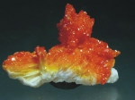
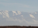
It was marvelous to see the Jbel Aiachi (3737 m high) covered with snow (ice valley). We also had a chance to see the Zaida Granite which is well known in Morocco. Subsequently we went to Midelt city, where there are lead mines (Mibladen and Ahouli). It used to be a very rich town and looks a bit like a French city. Nowadays there is no exploitation anymore. The mineral which is very known in this city is the Vanadinite.
At the end of the day, it was getting dark, so the last formation that we were able to see was a coral formation dating from the Jurassic (200-145 Ma). The corals form a limestone test and live in colonies. They tolerate calm conditions and colonize high level zones where they find food.
It was a wonderful trip and we learned so many things. When we arrived at Errachidia we met the other part of our team in the hotel. Unfortunately our professor, Naima, had a bad accident as she stepped into a hole and broke her foot. Nevertheless she stayed during the whole expedition and even guided the last day.
DESA students with the help of Naima Hamoumi
 |
 |
 |
 |
Saturday, 2 December 2006
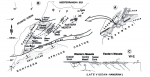
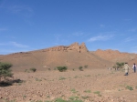
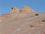
The first objective of this fieldtrip was Hollard mound. This Middle Devonian mound is situated near the eastern end of the Hamar Laghdad range. It was named after H. Hollard who first described its specific features. Hollard mound offers an excellent introduction to the world of the Devonian mud mounds because its inner structure is revealed. The mound core and the onlapping layers are perfectly visible.
Observations:
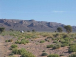
After lunch we set course for the actual Kess Kess mounds who are situated just a few kilometers to the east of Hollard mound. These mounds are slightly older and date from the Early Devonian but they nevertheless reveal a similar geometry. Nearly 50 mounds are reported in this area on top of a thick cover (to 180 m) of crinoidal sands and gravel.
Loubna, Esmeralda, Abdelfatah, Asmaa, Ahmad
 |
 |
 |
 |
 |
Sunday 3 December 2006
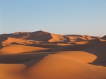
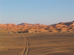
On the third of December we returned to the Kess Kess mounds to make a comparative study between the mound and intermound (= between the mounds) facies (= the type of rocks). The observations made by the student are written below. After lunch we did a socio-cultural excursion to Rissani. This city is the ancient capital of the Tafilalet area. For centuries it was the last stop for caravans on their way to the Sahara. Next the scientific party was introduced to the spectacular sedimentological phenomena of the Erg Chebbi. This is a field of sanddunes of 22 by 5 km where you can stardunes as well as barchans that reach up to 150 meters.
Observations:
During the second day of our field work our group continued the investigation of the Early Devonian conical mounds (kess-kess) of Hamar Lakhdad Ridge. We visited mound N° 19.
Our main targets were to compare deposits in the mound and intermound area and also try to understand the mechanisms that could form their conical shape with steep slopes and subcircular to subelliptical shape in cross section.
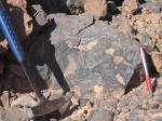
First of all, we noticed clearly a subhorizontal stratification of the intermound sediments. The layers in the flank of the mound rise up and are subparallel to the slope of the mound. Some of the mounds have been altered and lack the very top part.
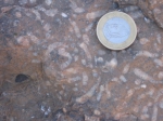
As for the type of the rocks, we sampled both the mound and the intermound facies but did not find considerable differences. The rocks appear to be quite similar and are lime mudstone to wackestone, containing corals, crinoids, trilobites and brachiopods. Several Neptunian dykes (dykes filled with sediments) have been observed in the mounds, the intermound limestones and the underlying crinoidal limestones.
Various mechanisms that are able to form the conical shape of the mounds have been discussed. A first hypotheses is the microbial activity that helped to cement the mound sediments, a second suggestion is that the sediments underwent early diagenesis, but the question remains what the reason is for this process.
Furthermore there were some other interesting details we noticed. For example, the red-coloured areas in the crinoidal limestones that can be observed at the very top of the outcrop. It would be interesting to know wether they are just at the surface or whether this alteration can be detected deeper, for example as a result of thermal influence.
To summarize we can state that for further understanding of the mechanisms that formed the conical carbonate mounds we will need good analyses and data.
Kolganova Julia, Chafik Mustapha, Chiguer Adil, Magdouline Saadi, Naima Mouden, Moad Akale
 |
 |
 |
 |
 |
 |
 |
Monday 4 December 2006
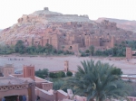
The fourth of December was a transfer day to Ouarzazate. Nevertheless, in the morning, Naima Hamoumi showed the participants two Ordovician (486-444 Million years ago) outcrops where impressive glacial features were visible. The observations of the students are written below (station 1 en 2). We spent the night in the UNESCO World Heritage Site of Ait-Ben-Haddou. This is a fortified city or 'ksar' along the former caravan route between the Sahara and Marakech. Some of you may recognize this city because it is featured in the film 'the Gladiator'.
Station 1: The Khabt Lahjar succession
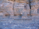
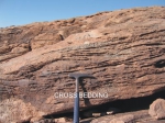
In this station we observed a succession dating from the Ordovician. It was possible to recognize siliciclastic depositions mixed with carbonate layers which were intercalated with limestone in some cases. The siliciclastic material comes from the Saharan ice sheet (During the Ordovician Morocco was situated near the South Pole) while the carbonate comes from bryozoan mounds and banks. In this 'mixed facies' layer we were able to identify several sedimentary features:
Furthermore we observed some limestone layers which were rich in iron minerals. We recognized the iron minerals by the reddish colours. According to Naima there were also ooliths (sediments that are composed of little balls, called ooides) present in this station but unfortunately we could not find them. We also observed very few fossils in this station.
Station 2: Rosf Al Hamra succession crops out in khabt lahjar area 19 km east of Erfoud city
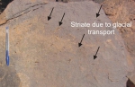
In this station glacial to periglacial (= near glacial) deposits were observed. The facies of the layers reflects sedimentation in a tide dominated delta under glacial control. We found huge blocs resulting from the physical weathering during a cold climate. We noticed similar polygonal features as in the first station and almost no fossils. Furthermore striate (=lines) were visible on the surface of the blocs indicating the direction of displacement due to glacial transport.
Esmeralda, Amine, Rabi, Naoual, Karima
 |
 |
 |
 |
 |
 |